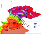
Introduction: The October 2005, Kashmir earthquake main event was triggered along the Balakot-Bagh Fault which runs from Bagh to Balakot, and caused more damages in and around these areas. Major landslides were activated during and after the earthquake inflicting large damages in the area, both in terms of infrastructure and casualties. These landslides were mainly attributed to the minimum threshold of the earthquake, geology of the area, climatologic and geomorphologic conditions, mudflows, widening of the roads without stability assessment, and heavy rainfall after the earthquake. These landslides were mainly rock and debris falls. Hattian Bala rock avalanche was largest landslide associated with the earthquake which completely destroyed a village and blocked the valley creating a lake.
Discussion: The present study shows that the fault rupture and fault geometry have direct influence on the distribution of landslides and that along the rupture zone a high frequency band of landslides was triggered. There was an increase in number of landslides due to 2005 earthquake and its aftershocks and that most of earthquakes have occurred along faults, rivers and roads. It is observed that the stability of landslide mass is greatly influenced by amplitude, frequency and duration of earthquake induced ground motion. Most of the slope failures along the roads resulted from the alteration of these slopes during widening of the roads, and seepages during the rainy season immediately after the earthquake.
Conclusion: Landslides occurred mostly along weakly cemented and indurated rocks, colluvial sand and cemented soils. It is also worth noting that fissures and ground crack which were induced by main and after shock are still present and they pose a major potential threat for future landslides in case of another earthquake activity or under extreme weather conditions.
